

Peru
Emilo Mateo, PhD Candidate
High mountain glaciers are the water towers of the Andes and fundamentally important to large population centers situated below. In Peru, home to more than 90% of Earth’s tropical glaciers, changes in glacier environments are accelerating beyond the rate observed anywhere else on the planet. The rapid disappearance of tropical glaciers is directly impacting the quality and quantity of local water supplies as well as the frequency and magnitude of glacier-related hazards (outburst floods, avalanches, landslides, and debris flows), and will have significant consequences for regional and international border security. These increased risks necessitate effective monitoring programs and require that we better understand the complex natural-human systems interactions involved before effective risk mitigation plans can be constructed. However, traditional scientific methods of observing mountain glacier-water systems are often complicated by the extreme altitude, steep slopes, and dense Amazonian cloud cover which obscures satellite observation. Two critical questions remain without answer: A) How much water remains preserved in the ice and what is the rate of change? B) How are changes in climate and glacier volume affecting mountain hazard frequency and magnitude?
OSU faculty and student researchers have spent decades in Peru cultivating relationships with local stakeholders and government agencies. Professor Bryan Mark’s Glacier Environmental Change Lab is focused on understanding how to predict future evolution of glacier-related water scarcities and cascading hazard chains. As a PhD candidate in this lab, I am grateful to have had the opportunity to address some of the scientific needs and challenges outlined above. To this end, I have spent my time at OSU designing, building, testing, and deploying custom sensors and drones capable of capturing critical data in the previously unstudied upper reaches of these harsh, high-mountain mountain environments (while also reducing exposure risk to our field researchers). We coordinate our mapping campaigns with Peruvian agencies (INAIGEM, ANA, IGP), co-generate our ongoing research priorities, and work together to generate the knowledge needed to reliably inform policy.
In 2019, after years of preparation, we successfully conducted a series of sustained, highly coordinated observations from instruments in orbit, in the air, and on the ground. I tested our new drone technology over various combinations of snow, ice, and rock over tropical glaciers. I also had the opportunity to work in coordination with NASA's ICESat-2 team, who agreed to point the newly operational ATLAS laser altimetry system at my study sites. Throughout the 2019 field season, I used this combination of passive and active sensor tech (lidar, infrared, optics) to collect a wide range of data that will be used to evaluate hazard risk, water security, and glacier physics. I will integrate these drone sensor data with OSU, NASA, and Peruvian observations collected over the past three decades from spaceborne, airborne, and ground instruments during collaborative research expeditions.
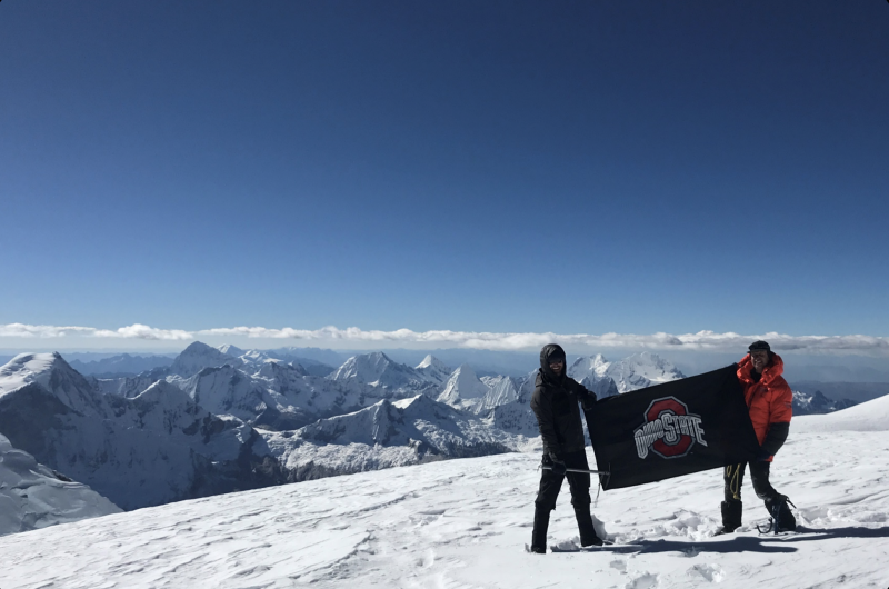
While in Peru, I also had the opportunity to join Professor Lonnie Thompson’s expedition to extract the highest ice core ever recovered in the tropics or in the Southern Hemisphere at 6768 m (22,205 ft). After joining this team, I vertically ascended 3718 meters (12,199’) and trekked 196km over snow, ice, crevasses, and cliffs to successfully collect unprecedented geodetic observations (GPS, laser altimetry), glaciological data (ice cores, strain measures, and snow samples), and geophysical measures (penetrating radar, borehole thermometry) while enduring harsh winds, white-outs, frost-bite, and hypoxia.
Throughout the austral winter of 2019, we acquired large volumes of data that will fill many gaps in our knowledge, and I am presently working to map change rates in glacier conditions and slope-stability using Byrd Polar & Climate Research Center lab equipment and the Ohio Supercomputer. We currently have the potential to provide many answers to these pressing questions with data of unprecedented extent and quality. However, the volume of this data is also unprecedented and requires additional efforts. Working with our Peruvian partner agencies, these research activities will improve our capacity to observe hazard and ice dynamics at finer scales, better understand the processes that drive them, and predict the future evolution of glaciers as both water resources and hazards. I am grateful to the OSU Department of Geography, Innovation Commons, Center for Latin American Studies, The Tinker Foundation, and College of Nursing’s Innovation Studio for their support. Together, we are advancing our scientific understanding of environmental hazards and water scarcity in a rapidly changing world.
Decolonized Afterlife: Toward A New Understanding of the Political Processes Surrounding Indigenous Death
Deondre Smiles, PhD
Boozhoo! My name is Deondre Smiles. I am a recent graduate of the OSU Geography Department (Ph.D., 2020) and a citizen of the Leech Lake Band of Ojibwe. In August 2020, I will begin a postdoctoral fellowship through the Departments of Geography and History here at OSU. My dissertation project, “Decolonized Afterlife: Toward A New Understanding of the Political Processes Surrounding Indigenous Death” focused on the different viewpoints on treatment of the Indigenous body after death by the settler colonial state/settler colonial structures and Indigenous peoples, paying particularly close attention to the political processes that surround the deceased Indigenous body, and the implications that they have for the continued resiliency and sovereignty of Indigenous nations.
My dissertation fieldwork, which began in the summer of 2018, was comprised of several methodological approaches. I collected archival material from the University of Minnesota Duluth’s Archives. I also conducted archival at the University of Minnesota Twin Cities’ Archives in Minneapolis. I also conducted interviews and oral histories beginning in 2018 through the spring of 2020, including both Indigenous and non-Indigenous participants, in a variety of sites across Minnesota, and Ohio, including on-reservation and off-reservation sites, a university autopsy center, and a coroner’s office.
The 2019-20 academic year consisted of multiple short fieldwork trips as I continued to build relationships with my research participants and moved closer to the conclusion of my dissertation research. It also resulted in some unique challenges; my final fieldwork trip occurred as the COVID-19 pandemic was beginning to spread in the United States; in fact, Ohio State cancelled all further University/departmental sponsored travel just as I landed in Minneapolis to begin my trip! Additionally, the nature of my interviews and data collection changed on the trip itself—in-person interviews became phone interviews, and some interviews simply were unable to take place, for example.
Fieldwork is very important to me and the type of work that I do—I view it as absolutely essential. Beyond its utility to my work, I am thankful to have built many important relationships and friendships via fieldwork. However, in a world where COVID-19 appears more and more to be part of everyday life, I also believe we will need to find ways to be able to conduct such work in ways that do not cause harm to ourselves OR harm to the communities in which we work—community and participant safety are also of vital importance to me as an Indigenous academic and researcher. These new ways of conducting fieldwork will ensure that we can continue to engage in robust, empirical—and ethical data collection and collaborative work in the new geographies that COVID-19 has placed upon us.
Bolivia
Gabo Zeballos-Castellon, PhD Candidate in Geography
As other colleagues have previously posted in this blog, un-immersive fieldwork1has endless options that can unravel new ideas and research approaches. Inspired by Max Woodworth’s re-visitation to his photographic archives, I started looking back at my pictures of Bolivia–both my native land and my dissertation study site. Ever since I moved to the US in 2016, I have been able to go back to my home country only twice per year, and only for a few weeks each time. This means that my photographic collection is intrinsically incomplete chronologically. However, when re-imagined as scattered pieces of a puzzle and integrated with images from other sources, it is possible to recognize some intriguing“before-and-after” stories. These other sources are various and somewhat unorthodox: Google Earth imagery, online newspapers, sometimes even pictures from unrelated trips. Capturing either the aftermath scenes or unplanned “beginnings,” these images accompanied my journeys researching mountain ecosystems in Bolivia. The stories that these images narrate remind us that the impacts of climate change are true and tangible even in very short intervals of time.
For example, in July 2016, I joined my co-advisor Karina Yager from Stony Brook University on a few trips to the Bolivian Altiplano. We were surveying potential study areas for future research on bofedales (high altitude wetlands of the Andes). While in the Hampaturi Valley, we observed the surroundings of a water reservoir and took some casual pictures of the site. What I did not know at that moment is that a few months later, the drought caused by the 2015-2016 El Niño would completely dry out the reservoir. When I came back to Bolivia in December that year, I was able to see it with my own eyes. The scene was heartbreaking. Not only were a quarter of million people of La Paz left without water service for months, the vegetation was also dead, the birds were gone, and the dry bottom of the reservoir revealed something that surprised me: the reservoir for the city’s drinking water was built over a former bofedal. The reservoir dried out as a consequence of El Niño 2016.
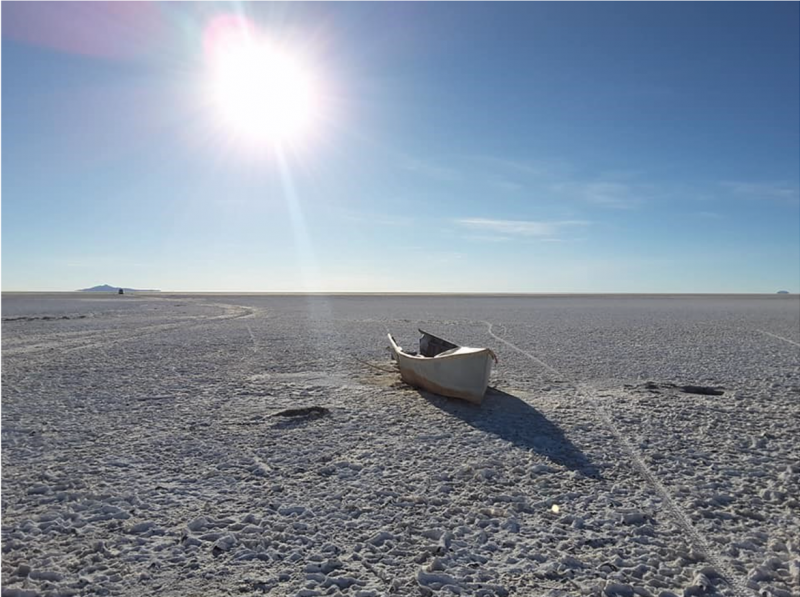
That was not the only body of water that dried out that year. The second-largest lake in Bolivia, Lake Poopo, also disappeared. I visited the lake from the coastal town of Huari on June 2017. Despite some recuperation of the water levels in the previous months, I could observe the abandoned boats. The soil was strikingly salt and the bottom was dry as far as the eyes could reach. It reminded me of the pictures I had seen from the Aral Sea. In August 2019, I went back to Huari. I was on a field trip to the Bolivian Southern Altiplano. I took a short detour from my way. I needed to go back to the same place where I saw the abandoned boats in 2017. This time there were no boats, but also, almost no water. My powerful camera was able to capture some water bodies far on the horizon. Flocks of flamingoes were present. To see wildlife always warms the heart, although I knew that the economic activities of the anglers were never going to recover to levels of the past. The former anglers probably had migrated to other regions already by that time. They are climate refugees. The second-largest lake in Bolivia dried out several times in the past five years.
Two thousand nineteen was also a hard year for my hometown, La Paz. In January, a landslide wiped out an entire segment of the Llojeta neighborhood, a sector built a couple of decades ago over a former waste landfill. Even 11 months later, when I took a picture from a cable car, the area still looked destroyed and under risk of collapse. An image from the History tool from Google Earth can give a better idea of how Llojeta appeared before the landslide. It is not news that Google Earth has this useful application to view several older images of scenes, but to be able to capture a picture from the terrain gave me a better idea of the scale and magnitude of the event.
Later that year, the Amazon Rainforest from Bolivia and Brazil suffered one of the worst wildfires in recent history. I happened to visit one of the most impacted sites a few months before of the beginning of the wildfires. The site of the picture is called the Serranía de Chochis. Besides its natural beauty and biological richness, this region belongs to one of the UNESCO’s World Historical Heritage sites: The Jesuit Missions of the Chiquitos. The wildfires destroyed over 6 million hectares only in Bolivia.
In the early nineteenth century, the French explorer Alcides D’Orbigny commented about his travels through South America: “If the Earth disappeared, leaving only Bolivia, all the products and climates of the world would still exist. Bolivia is the planet’s microcosm. Due to its height, its climate, and its infinite variety of geographical nuances, Bolivia becomes the synthesis of the world.” For almost two centuries, D’Orbigny’s descriptions and travel logs were the single piece that portrayed Bolivia’s natural and cultural richness. Today, his images comprise a new puzzle that is excruciating to fill. A puzzle where Bolivia is still a microcosm of the Earth. Only that this time Bolivia is becoming the synthesis of environmental degradation and global climate change that affects the world at large. Can we, as a global society, be an active part of the restoration of our common house?
Great Basin
Bryan Mark, Professor
It has been a productive year for the Department’s ongoing student-centered experiential research projects in Great Basin National Park, part of the “GBEX” program (https://geography.osu.edu/GBEX). In the summer of 2019 Departmental faculty, staff and students visited the Park for the 13th year in a row. The 2019 crew consisted of Bryan Mark, Jim DeGrand, and undergraduate majors Aiden Dalby and Sydney Smith, engineering undergraduate Evan Vega, and OSU Innovation Studio staff member, Josh Wooten. Continuing a collaboration that dates back over a decade, we were joined in the field by University of Georgia Professor, David Porinchu, and Professor Scott Reinemann (ASP PhD, 2013), who recently took a tenure track appointment at Sinclair Community College in Dayton, OH.
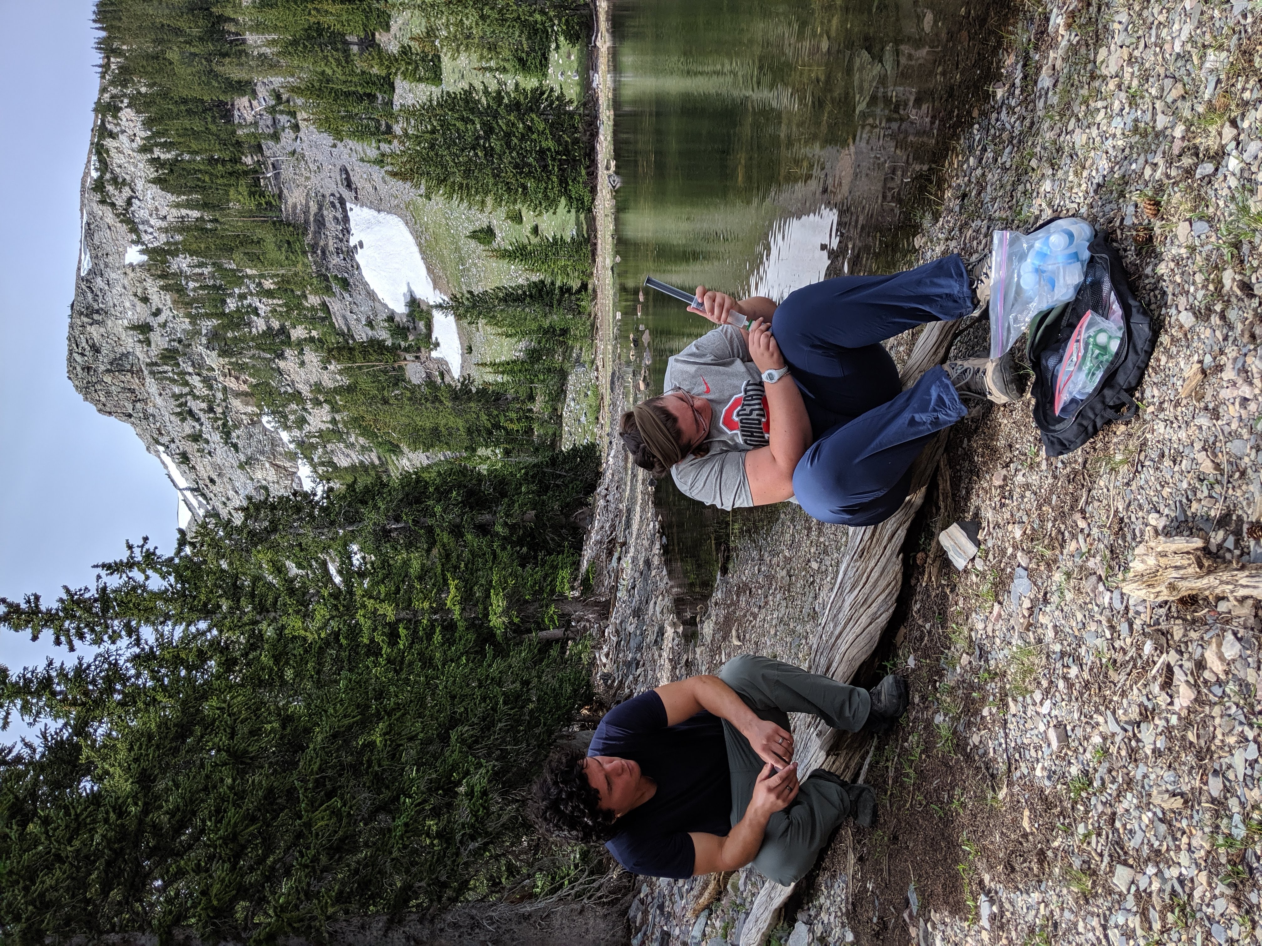
While in the field, we completed routine activities that veterans who have been on previous expeditions will, no doubt, remember fondly: servicing and downloading data from Lascar and I-button temperature sensors; switching batteries; measuring stream flows; and taking water samples from alpine lakes and streams. Under the student leadership of Evan, a lead engineer on the Mountain Drone Team (https://byrd.osu.edu/news/mountain-drone-team-connecting-people-science), we made a second geodetic mapping survey of the Lehman Rock Glacier using a drone and differentially corrected GPS control points. In addition, we opened a new chapter in our efforts to elucidate the history of fire within the Park. Following up on studies of charcoal deposited in lake sediment, in 2019 we took multiple tree cores from the pines growing near the lake in order to look at stand population and growth dynamics over the past several centuries. Preliminary results are promising as we were able to recover multiple cores dating back to the 15th and 16th centuries. We plan on extending this work in our future visits to the Park.
Back in Columbus, we have put our field activities to work in the service of scholarship. Emily Sambuco (ASP MS, 2019) along with co-authors Bryan Mark, Jim DeGrand, Nathan Patrick, Scott Reinemann, David Porinchu, Gretchen Baker and Jason Box, authored a paper on montane temperature regimes based on data from our sensor network in the Park. The paper has been accepted for publication in the Hydrosphere section of Frontiers in Earth Science. Sydney Smith used the same dataset to explore the concept of elevational warming in her poster presented at the Spring 2020 Undergraduate Research Festival (https://u.osu.edu/2020springfestival/student-presentations/college-of-arts-and-sciences/social-and-behavioral-sciences/sydney-smith-international-studies-geography/). Undergraduate Nischay Soni, 2018 GBEX veteran, presented a poster at the 2019 AGU Fall Meeting in San Francisco featuring the high-resolution, drone-based maps showing interannual changes of the Lehman Rock Glacier. Finally, we submitted a proposal to the Western National Parks Association to expand our fire history research; we were recently notified this proposal was accepted for funding.
As with virtually all human activities on the planet, the COVID-19 pandemic substantially impacted our plans for work in the Park in 2020. The risk associated with air travel along with requirements for quarantining following travel to Nevada forced us abandon our plans for this field season. Fortunately, our colleague Gretchen Baker, the Park ecologist, with whom we have forged a close, collaborative relationship, has volunteered to do the routine maintenance on our network of sensors in the Park. This will hopefully ensure that our hourly temperature and humidity data spanning over 13 years will not be discontinued. Here we see the value of building relationships with a network of stakeholders when undertaking field research. Moreover, given previously acquired sediment and tree cores stored in the Department’s Integrated Paleoecology Lab in the basement of Derby Hall, there are plenty of lab and data analyses that can continue. It takes a committed cohort of like-minded collaborators to sustain this project: we are grateful for the team we have in our Department, at our field site and with colleagues at other institutions.